The first thing that grabs your attention is the unexpected color of the water. As a plane crosses the South China Sea, the ocean abruptly shifts from deep blue to a cloudy turquoise, carved by straight lines that feel out of place in nature. Far below, dredgers as large as apartment buildings trace slow circles, spilling pale sand into the waves. Nearby, fresh concrete shines where only open ocean once existed. From the air, you can watch a nation reshape its own coastline in real time, transforming reefs and rocks into solid ground.
What were once isolated reefs and half-submerged stones now host runways, radar domes, and rigid gray roads that end sharply at the sea’s edge. Seen from above, the map itself feels deceptive. The land no longer matches what charts suggest, and the reason becomes obvious the longer you look.
From Coral Reefs to Concrete Airstrips
By depositing millions of tonnes of sand onto shallow coral reefs, China has carried out one of the most dramatic geographic transformations on the planet. Across the Spratly and Paracel island chains, areas once visited only by fishermen and storms have become fully formed artificial islands in less than a decade. Up close, the work appears almost mundane—pipes, pumps, sediment, concrete. From a distance, it feels astonishing, as if coastlines are no longer inherited but deliberately chosen.

Fiery Cross Reef is a clear example. Once little more than rocks and breakers, it began changing around 2014 when satellite images revealed a faint arc of sand forming around it. Month by month, that outline sharpened. Retaining walls followed, then a harbor, and eventually a runway stretching over three kilometers. Today, the reef supports hangars, radar systems, fuel depots, and a deepwater port, all built atop what was once open sea. Similar transformations have played out at Subi Reef, Mischief Reef, and others, repeating like a precise template across the region.

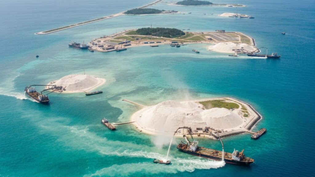
The Mechanics Behind the Expansion
The method itself is straightforward. Dredgers pull sand and sediment from the seabed and spray the slurry onto reefs just below the surface. Heavy machinery then compacts and shapes the land, while seawalls hold everything steady against tides and storms. After that comes the second stage: concrete, steel, asphalt, and the infrastructure that converts sandbanks into strategic outposts. This is more than construction—it is geopolitics set in cement, with each island extending airstrips, docks, and radar coverage deeper into contested waters.
Why These Artificial Islands Matter Worldwide
On paper, the process sounds technical and controlled. In reality, the underwater impact is severe. Coral reefs are buried beneath layers of sediment, suffocated much like cities under volcanic ash. Fish breeding grounds disappear overnight, and fishermen in the Philippines and Vietnam have described familiar waters turning lifeless, with cloudy seas and empty nets. Research from the Asia Maritime Transparency Initiative estimates that more than 15 square kilometers of reef have been destroyed or badly damaged—an area that may seem small on a map but represents immense loss for marine ecosystems.
The legal implications are just as complex. Under international maritime law, only naturally formed islands can generate territorial waters and exclusive economic zones. Artificial islands do not carry those rights. Yet once a runway, radar system, and harbor exist, the reality on the water shifts. Patrol routes extend, coast guard vessels act with greater confidence, and neighboring countries feel increasingly boxed in. Concrete poured into disputed seas cannot simply be undone, and each new structure subtly alters the balance.

What This Experiment Reveals
Land reclamation itself is not new. Cities like Singapore, Dubai, and Hong Kong have expanded this way for decades. The difference here lies in scale, speed, and location. Where others reclaimed land to relieve urban crowding, China has pushed outward into contested waters. Behind the machinery is a familiar human impulse: when space feels limited, boundaries are pushed outward. What begins as a “small improvement” can escalate into hardened runways and fortified ports, step by step.
Countries such as the Philippines, Vietnam, and Malaysia watch these developments with a mix of frustration and resignation. Diplomatic protests are filed, visiting warships appear, yet satellite images soon reveal more sand and more concrete. Legal statements fade into the background, while photographs of fresh runways shape public perception far faster.
- New land, old disputes: Artificial islands intensify sovereignty tensions rather than resolving them.
- Environmental damage first: Reefs, fish stocks, and local livelihoods bear the immediate cost.
- Maps as influence: Images of new infrastructure affect opinion more quickly than legal arguments.
Living in a World Where Coastlines Shift
Once you notice what is happening in the South China Sea, similar projects appear everywhere: airports built offshore, waterfronts extended, luxury islands shaped into symbols. The principle is simple—if land is lacking, it is created. This raises difficult questions about who decides the shape of future coastlines: engineers, investors, navies, or the communities that depend on the sea.
Many people recognize the feeling of seeing a familiar place transformed—a forest replaced by a mall, a quiet beach lined with buildings. Now imagine that same rewriting happening far offshore. The blue spaces once thought permanent are being quietly edited, with effects that ripple outward. Changes to fishing grounds influence food supply, altered sea lanes affect trade, and rising military presence reshapes budgets and security concerns.
The reality is unsettling: once you understand how easily coastlines can be moved, the world feels less fixed and more negotiable. China’s artificial islands are a striking example, not an isolated case. As sea levels rise and competition for space grows, more nations will attempt similar projects—some for protection, others for expansion. The next time you glance at a digital map, remember it is only a moment in time. Somewhere, under a bright sky, another dredger is already drawing a new line across the sea.

- How new islands are built: Massive dredgers pump sand onto reefs, which is then compacted and fortified, helping you visualize the physical process behind the headlines.
- Environmental and legal consequences: Reefs are buried, fisheries suffer, and maritime law is tested, showing why this issue connects to food, climate, and security.
- Looking ahead: As land reclamation spreads globally, it forces us to ask who will shape tomorrow’s coastlines and at what cost.