The moment everything began to change didn’t resemble a blockbuster disaster scene. It arrived quietly, wrapped in an odd calm. The air felt unusually sharp, the stillness unsettling. In Chicago, a father stepped outside to take out the trash and noticed the stars shining with rare clarity. He paused and muttered that it felt like February had arrived too soon. In Berlin, a woman refreshed her weather app repeatedly, convinced it was malfunctioning after showing a sudden, severe cold snap following an unseasonably mild stretch.
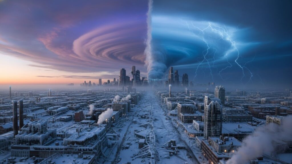
Far above them all, nearly 30 kilometers over the Arctic, a much larger shift was underway. The polar vortex—a massive loop of freezing winds circling the North Pole—was beginning to bend, weaken, and fracture.
For most people, nothing felt different.

For meteorologists, everything did. And the signals they’re tracking suggest February could dramatically reshape winter conditions.

A Powerful Force in the Atmosphere Starts to Falter
Think of the polar vortex as a spinning top made of jet stream winds and extreme cold. When it spins quickly and stays compact, Arctic air remains locked near the pole. When that spin slows or becomes unstable, cold air can escape southward, much like marbles sliding off a tilted surface. Right now, atmospheric observations and forecast models show that top beginning to wobble.
The term quietly circulating among experts—sometimes whispered, sometimes posted openly online—is “sudden stratospheric warming.” This phenomenon refers to a rapid temperature increase high above the Arctic that can disrupt or even flip the polar vortex.
This pattern isn’t new. In early 2021, a major polar vortex disturbance helped drive the devastating Texas freeze, pushing Arctic air into regions unaccustomed to severe cold. Europe experienced a similar episode in 2018, when the so-called “Beast from the East” buried cities under ice and sent heating costs soaring for weeks.
Now, forecast centers across the US, UK, and Europe are highlighting familiar warning signs: warming in the stratosphere, weakening circular winds around the pole, and a vortex that appears ready to split and drift. Several models depict cold air stretching toward North America and Eurasia as February begins. This doesn’t guarantee extreme weather—but it significantly raises the risk.
Why a Shift High Above Can Change Everything Below
In simple terms, warm air surges upward toward the pole in the upper atmosphere, acting like a shockwave. That surge interferes with the polar vortex’s usual west-to-east rotation, slowing it down or even reversing its direction. As a result, high pressure builds over the Arctic, nudging trapped cold air southward.
At ground level, this can trigger a sudden transition from dull, mild winter weather to biting cold and snowfall within days. Typically, there’s a delay of one to three weeks between a polar vortex disruption and extreme surface conditions. That window lines up squarely with February.
What February Could Bring to Daily Life and Household Costs
You don’t need technical expertise to respond wisely. A simple but effective step is to monitor medium-range forecasts more closely over the next few weeks. Focus on 7–14 day outlooks that highlight pressure patterns and cold air movements, rather than long-range predictions that lack precision.
For those in the northern United States, Canada, the UK, and much of central and northern Europe, an unstable polar vortex often means sharp cold spells, icy roads, and intense snowfall. This is a good moment for low-key preparation—checking that your car’s winter gear includes more than a worn scraper and a nearly empty de-icer.
 Goodbye Hair Dye for Grey Hair: The Conditioner Add-In That Gradually Restores Natural Colour
Energy use is another critical concern. Cold surges following a vortex disruption can send heating demand soaring almost overnight. Many people know the feeling of opening a utility bill after a cold snap and pausing in disbelief.
This year, energy networks are already under strain, with high prices and tight supplies in several regions. A February cold outbreak could lead to sudden bill increases, pressure on power grids, and difficult decisions for households. The goal isn’t panic buying—it’s practical steps now, such as draft blockers, insulated curtains, and properly bled radiators, which can reduce costs when temperatures plunge.
Early Signals Worth Paying Attention To
Scientists are working to translate this complex atmospheric behavior into useful guidance. One senior atmospheric researcher described the current outlook as “a loaded dice scenario—not a certainty, but a strong signal.”
Another European climate scientist noted that while the phrase “polar vortex” often sounds like media hype, the system itself is very real. When it destabilizes, everyday life becomes more difficult—affecting transport, energy supply, and public health.
- Watch for repeated references to sudden stratospheric warming in forecasts.
- Check whether your energy provider offers alerts or budget plans ahead of cold surges.
- Monitor jet stream maps in reliable weather apps for deep southward dips.
- Allow flexibility in travel plans, especially during the second half of February.
- Reach out early to older relatives or neighbors about cold-weather support.
A Winter Balancing Between Warming and Instability
This season carries a striking contradiction. While the planet continues to warm overall, with record global temperatures and shrinking Arctic sea ice, we’re also facing a familiar winter threat: a destabilized polar vortex capable of delivering intense cold. Both realities coexist, even if they seem hard to reconcile.
Climate change doesn’t eliminate cold winters—it makes weather patterns more erratic. Some researchers believe a warmer Arctic may actually increase vortex instability by narrowing the temperature difference between the pole and mid-latitudes. Others urge caution, noting the science is still evolving. For most people, the debate matters less than whether pipes freeze or schools close.
Few have time to read dense climate reports. What people notice instead are the patterns: snow replacing rain, slush replacing powder, and rapid swings between unseasonable warmth and sudden deep freezes. The weeks ahead may amplify that sense of unpredictability.
A potential February shock also highlights how interconnected the world has become. A shift in Arctic winds can influence energy demand in France, road salt supplies in the Midwest, and hospital admissions in Eastern Europe. One disrupted circulation pattern sends ripples across industries and communities simultaneously.
If the most severe outcome unfolds, scenes will emerge everywhere: frozen fountains in cities unused to ice, vulnerable populations caught in the cold, commuters navigating black ice before sunrise. The real question isn’t just whether temperatures will drop—it’s how we use the rare warning window between atmospheric signals and real-world impact.

| Key point | Detail | Value for the reader |
|---|---|---|
| Polar vortex disruption is likely | Signs of sudden stratospheric warming and weakening high-altitude winds over the Arctic | Helps you understand why forecasters are suddenly talking about extreme February patterns |
| February cold waves become more probable | Cold air can spill south into North America and Europe 1–3 weeks after the disruption | Gives you a rough time window to follow forecasts and plan travel, heating, and work |
| Small preparations matter | Energy use, transport, and everyday routines can all be disrupted by a rapid temperature flip | Encourages concrete steps — from home insulation tweaks to checking on vulnerable people |