On a calm February morning in a Boston suburb, the weather seems ordinary. Children trudge through slushy sidewalks to school, someone scrapes frost off their old Honda, and the local forecast mentions “seasonal temperatures.” There’s nothing that stands out as dramatic. But above those quiet streets, the stratosphere is in the midst of an unusual transformation. The air, which should be freezing cold, is warming rapidly. An invisible thermal upheaval is brewing over the Arctic, and scientists are sounding alarm bells with more urgency than usual.
One scientist likens it to “watching the gears of winter grind and slip.” Something big is rewiring the season in real time.
Winter Might Not Be What We Expected
Across the globe, meteorologists are monitoring an early stratospheric warming event that’s not only rare but also unusually strong for February. This isn’t a minor disturbance like a slightly “wobbly” polar vortex. Instead, it’s a rapid, intense warming happening tens of kilometers above us—strong enough to disrupt wind patterns that usually trap the cold air. When those winds reverse, the consequences ripple downward, affecting the weather we experience on the ground.

What appeared to be a settled winter just weeks ago is now back in play.
Why This Sudden Stratospheric Warming Matters
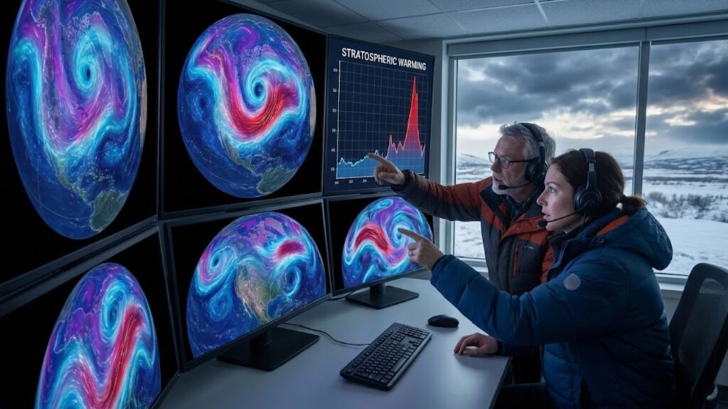
Right now, if you scroll through weather Twitter, you’ll see the same maps appearing over and over again: swirling images of the Arctic, with hot red zones replacing the usual deep blue. One European model predicts that the stratosphere over the pole could warm by 40–50°C in just a few days, where temperatures typically hover around –60°C. Another graphic shows the polar vortex—once a tight ring of icy winds—stretching, cracking, and splitting in two like a fragile egg.
For cities like New York, Berlin, Tokyo, or Chicago, those eye-catching graphics could translate into something tangible: in the weeks that follow, the region could experience stuck cold air, snowstorms, or unexpected warmth.
Scientists call this event a “sudden stratospheric warming” (SSW). While it happens some winters, this one stands out because it’s happening early and intensely. February is usually when winter falls into a predictable rhythm. But a strong SSW is like shaking an Etch A Sketch. The stratosphere heats up, winds shift, and that energy slowly trickles down, altering jet streams, storm tracks, and high-pressure systems.
As a result, several forecasting centers are quietly adjusting their winter outlooks right now.
How an Invisible Warm Blast Affects Your Local Weather
To understand the impact of this warming on your local weather, it’s helpful to stop fixating on the 7-day forecast. Instead, think in terms of weeks, not days. An SSW is more like a large steering wheel turning the entire atmosphere, not a sudden thunderstorm. You won’t feel the effects immediately—it takes time to trickle down.
Over a 10–20 day period, this high-altitude warming can break up or shift the polar vortex, sending cold air rushing into some regions while others experience an unexpected mild spell.

Here’s the common misunderstanding: When we see a headline about the “polar vortex collapse,” we often expect a snowstorm right away. But it rarely happens that fast. The atmosphere moves slowly. There’s usually a delay of two to three weeks between the stratosphere’s upheaval and the weather we experience on the ground.
It’s like those times when you shovel the driveway in December, think “winter wasn’t that bad,” only to be hit by a surprise cold wave in March. That unexpected cold is exactly the kind of event triggered by a stratospheric shift.
What Meteorologists Are Really Saying
For those planning their lives—farmers, city planners, and parents with heating bills—flexibility is the key. This might sound vague, but it’s actually practical. Instead of expecting the usual winter, treat late February and March as a period of uncertainty. Keep your winter gear ready, but watch out for early signs of thawing, like muddy fields or early budding. Stay tuned to updated seasonal forecasts, especially those that mention a **negative Arctic Oscillation** or a disrupted polar vortex. These are the signs of a pattern being reshaped by high-altitude warming.
Many people feel deceived when a season flips unexpectedly. After a few mild weeks, you pack away your snow boots, turn down the heat, and make plans assuming the weather won’t be too bad. Then, a pattern shift triggered by a stratospheric event hits, and you’re stuck dealing with a late blizzard or relentless winds. Meteorologists know that forecasting specific snowfall a month ahead is nearly impossible, but they can see the risk growing.
So, here’s the advice: be skeptical of “winter’s basically over” talk, even if your local weather has been calm. Watch for reputable forecast centers updating their seasonal outlooks as the SSW unfolds.
Prepare for Impact on a 2–6 Week Horizon
- Expect more extreme swings: deep cold snaps, sudden thaws, or blocked weather patterns.
- If you work outdoors or in energy, account for “weather-flex” in your schedules and budgets.
- Remember, a dramatic SSW doesn’t guarantee snow at your house, but it does raise the chances of extreme weather somewhere.
What This Means for the Future of Winters
What makes this early warming event so unsettling is that it’s happening on top of a record-warm global ocean, a lingering El Niño, and cities already impacted by strange winters over the past decade. Some researchers are starting to ask whether these large atmospheric shifts will happen more frequently as our climate continues to warm. While they remain cautious, the question is becoming more relevant.
For most people, it’s simpler: winter doesn’t feel as predictable as it used to. Maybe you’ve noticed the stop-and-start seasons, the winters that don’t show up until March, or the ones that turn into endless rain instead of snow. This early February warming event could just be another oddity in the weather data. Or, it might be the spark that transforms a quiet winter into one people will remember for years.
Either way, it’s a reminder that we need to pay more attention to the hidden dramas unfolding above us. The forecast is no longer just about the next storm; it’s about how a warming world is changing the rhythm of entire seasons.
 Scientists identify the age when happiness drops sharply and the explanation is not what you think
| Key point | Detail | Value for the reader |
|---|---|---|
| Rare early SSW | Unusually strong February stratospheric warming disrupting the polar vortex | Signals that the rest of winter may look very different from what was expected |
| Lagged impacts | Weather effects often show up 2–6 weeks after the warming event aloft | Helps you understand why forecasts change and why late-season cold or warmth can surprise |
| Pattern, not days | Focus on broader patterns like jet stream shifts and Arctic Oscillation phases | Lets you read seasonal risks better than just staring at a 7‑day forecast app |