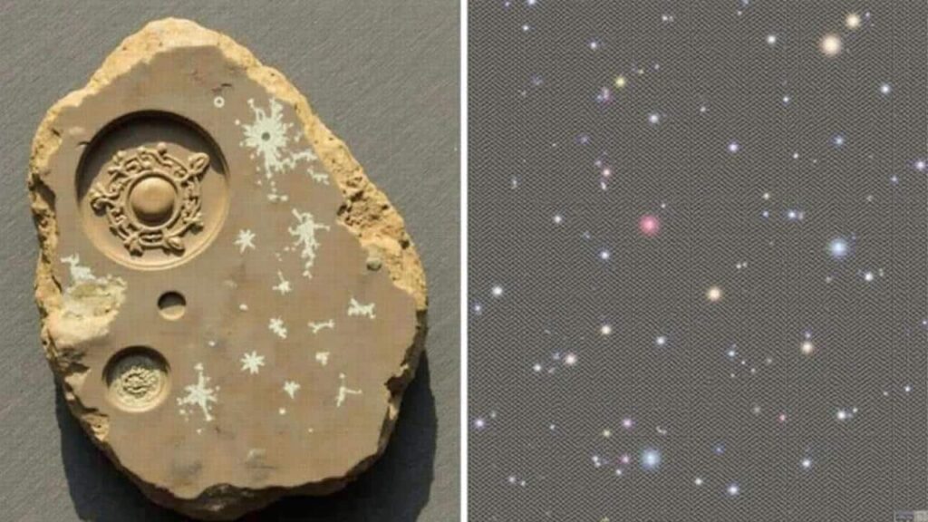
Near the tiny village of Skobelevo, in the rugged Rhodope Mountains, researchers say a weather‑beaten boulder could be far more than a curious geological feature: it may be a hand‑made map of the night sky created thousands of years ago.
A walk in the woods that changed direction
On 20 May 2013, Bulgarian researchers Georgi Georgiev and Ivelina Georgieva were trekking through a wooded slope near an ancient Thracian necropolis. The area had been surveyed many times, but mostly for tombs and ritual structures, not for rocks lying off quiet paths.
That day, a large stone partly buried in the undergrowth caught their eye. It sat at an unusual angle, aligned roughly east–west, with a bright stripe of white marble running across its darker surface. In the dappled mountain light, the vein looked almost like a pale river crossing the rock.

Curiosity pulled them closer. Brushing away leaves and soil, they realised the surface was not smooth. It had been worked. Dozens of small, conical cavities had been carefully carved into the rock, some wider, some narrower, arranged in what looked suspiciously like a pattern.
 French foreign trade surges in Chinese Sichuan province with 32.7% export jump to €432 million
The stone holds 56 carved hollows, split between its northern and southern halves, with a precision that seems anything but random.
Measurements taken later showed the boulder is about two by three metres. On its “northern” side, 24 depressions. On the “southern”, 32. For Georgiev, long familiar with natural erosion forms, the symmetry and clean carving argued strongly for human hands and a deliberate design.
From cavities to constellations
Once the first sketches and photographs were brought back to the lab, the pattern started to look eerily familiar. Several clusters of cavities lined up in a way that matched known constellations in the northern sky.
Ursa Major – the Big Dipper – appears to stand out most clearly, along with Leo. Other, slightly looser groupings seem to echo Cassiopeia’s “W” shape, the cross of Cygnus, the compact pattern of Lyra, and the tight knot of the Pleiades.
That match is what triggered a wave of archaoastronomical interest. Could this be a prehistoric chart of the stars rather than just an abstract ritual carving?
The varying sizes of the hollows seem to reflect stellar brightness, suggesting a deliberate attempt to show which stars shine stronger in the night sky.
According to Georgiev, the north–south division on the stone might represent a conceptual split between two halves of the sky, much like astronomers today talk about celestial hemispheres. The larger cavities could mark first‑magnitude stars, while smaller ones trace fainter points of light.
A stone calendar for farming and ritual
Co‑researcher Ivelina Georgieva has floated a bold interpretation: the rock may have served as a stellar calendar. By tracking which carved constellations climbed above the horizon at different times of year, local communities could time planting, harvesting, and seasonal rites.
For Neolithic or early Iron Age societies, the night sky was not an abstract curiosity. It was a timetable. Seasonal changes in the appearance of constellations offered a predictable framework for planning work and ceremonies long before written calendars existed.
Georgieva argues that the Skobelevo stone records a careful, long‑term reading of the heavens. People would have watched, year after year, where stars rose and set, then translated that understanding into the arrangement of hollows on the rock.
Glitter, mica and the Milky Way line
The stone’s visual impact would have been strong even by daylight. The carved surface contains mica, a mineral that sparkles in the sun. Under direct light, this creates a subtle, shifting glimmer around the cavities.
Combine that with the broad white marble vein running across the rock, and you get a striking effect: a pale band crossing a field of bright points. For the researchers, that band strongly evokes the Milky Way arching over a star‑filled sky.
The rock seems designed to evoke a living sky: a shimmering band like the Milky Way cutting through a field of “stars” chiselled in stone.
The choice of such material may not be accidental. In many prehistoric sites, reflective stones, crystals or heated surfaces appear in places where ritual or sky‑watching activities seem likely. Light effects can heighten emotion, focus attention and lend a sense of drama to collective gatherings.
A second stone points east
The setting strengthens the astronomical reading. Near the carved boulder, the team identified a second stone with a cylindrical cavity, oriented toward the east.
This alignment might have worked like a primitive sighting tube, allowing observers to mark the heliacal rising of key stars – the moment a star first becomes visible at dawn after being hidden in the Sun’s glare. Many ancient cultures, from Egypt to Mesopotamia, used such risings to mark the start of agricultural seasons or religious calendars.
Seen together, the “star map” stone and the east‑facing stone start to look like parts of a small open‑air observatory rather than isolated curiosities.
How old is Bulgaria’s possible star map?
Dating the Skobelevo rock has proved tricky. No pottery shards, bone fragments or charred remains have turned up around the boulder so far. That rules out radiocarbon dating and stratigraphic analysis for the moment.

Instead, the team has turned to comparisons with nearby archaeological sites. The region is rich in Thracian tumuli and necropolises, many used from the late Neolithic through the early Iron Age.
Based on this context, Georgiev and his colleagues currently place the carving somewhere between 2000 and 500 BCE. That still leaves a broad window of more than a thousand years, but it suggests the rock belongs to a period when sky‑oriented sanctuaries were already a feature of the Balkan landscape.
Without organic remains to test, researchers rely on nearby tombs and ritual sites to tentatively date the star stone between the late Neolithic and the dawn of the Iron Age.
Links to other Balkan sanctuaries
Across the Balkans, several prehistoric sanctuaries show alignments with solar events, such as the winter and summer solstices, or with the rising of bright constellations. Stone rows, cut channels and built platforms frequently line up with sunrise or sunset on key days of the year.
Skobelevo seems to stand within this broader tradition. The rock may represent a local approach to the same basic goal: tracking cyclical events in the sky to give structure to life on the ground.
A fragile piece of heritage at risk
Despite the potential significance of the find, the Skobelevo stone currently has no formal protection. It sits in a forest clearing, accessible to hikers, loggers and curious visitors without supervision.
Weathering, plant growth and simple human negligence could gradually erase or damage the carvings. Graffiti, fire or attempts to chip away “souvenirs” would be even more destructive.
The rock lies outside any official protection zone, leaving one of Europe’s most intriguing prehistoric artefacts exposed to erosion and vandalism.
Georgiev and Georgieva have urged Bulgarian authorities to list the site in the national register of archaeological monuments. Such status would support basic conservation measures and possibly controlled access for researchers and tourists.
So far, studies have focused on non‑invasive methods: GPS mapping, sun‑rise and sun‑set observations and geological analysis of the stone. These point strongly toward human carving and consistent astronomical alignments, but more work is needed to verify the competing hypotheses.
Why prehistoric people mapped the night sky
For people living several thousand years ago, the sky was a practical tool, a spiritual guide and a shared reference point. A carved “map” like the Skobelevo stone may have fulfilled several roles at once.
- A farming timetable: seasonal star patterns can guide planting and harvest dates.
- A ritual stage: gatherings timed to solar or stellar events reinforce group identity.
- A navigation aid: constellations help travellers maintain direction at night.
- A teaching device: elders can show younger members how to read the sky.
By fixing parts of the sky on a rock, a community turns changing, fleeting stars into something stable and enduring. That anchored knowledge can then be passed through generations, even if oral traditions shift or neighbouring cultures press in.
Understanding key terms and methods
What is archaeoastronomy?
Archaeoastronomy is the study of how past societies understood and used the sky. Researchers combine astronomy, archaeology, anthropology and history to see how monuments, carvings or texts relate to celestial events.
In practical terms, that might mean checking whether a stone row lines up with sunrise at solstice, or whether a cluster of dots on a cave wall matches the Pleiades. In Skobelevo’s case, it involves testing if carved hollows really mirror known constellations for the latitude and epoch in question.
Simulating ancient skies
One powerful tool in this work is sky‑simulation software. By entering a location and an estimated date, researchers can reconstruct the night sky as it would have appeared thousands of years ago, correcting for precession – the slow wobble of Earth’s axis that changes star positions over long time spans.
For Skobelevo, simulations can test several scenarios: does the pattern fit the sky around 2000 BCE better than 500 BCE? Do the presumed constellations line up with the rock’s north–south division? Does the east‑oriented stone frame the heliacal rising of a particular bright star, like Sirius or a key star in Leo?
| Question | What researchers check |
|---|---|
| Is it really a star map? | Statistical match between hollows and star positions for given dates |
| How was it used? | Links between alignments and seasonal events or ritual paths |
| How old is it? | Nearby sites, tool marks, erosion rates and sky reconstructions |
What this Bulgarian rock can still teach us
If the Skobelevo stone does turn out to be one of the earliest surviving star maps, it will reshape ideas about how fast and how far prehistoric astronomy developed in Europe. It would show that people in the Rhodopes were not only watching the sky, but encoding what they saw in a surprisingly systematic way.
Even if future work reveals a more complex or mixed function – part ritual symbol, part calendar, part landscape marker – the rock already raises a simple, powerful point: long before telescopes and observatories, communities invested time and skill into making the night sky intelligible. That effort links a forest clearing in Bulgaria to megaliths in Britain, petroglyphs in Scandinavia and stone circles in the Mediterranean basin.
For visitors and locals, the site also opens up a different kind of contact with prehistory. Standing by the boulder at dusk, watching modern constellations rise above the Rhodope peaks, it becomes easier to imagine people doing the same several thousand years ago, tracing lines between stars and chiselling their knowledge, one hollow at a time, into a glittering slab of rock.