The first thing that stands out is the color of the sea. From above the Spratly Islands on a clear day, the shallow waters should glow turquoise, like an untouched postcard. Instead, viewed from a patrol aircraft, the surface is broken by unnatural straight lines, sharp angles, and dull grey patches where vibrant reefs once thrived.
On one of these man-made formations, a Chinese flag flutters above a vast concrete platform. Radar systems rotate slowly. Long runways stretch across the island, while nearby warships rest in the water like heavy punctuation marks interrupting a fragile sentence.
No explanation is needed in the cockpit. Everyone aboard understands that this scene is no longer about fishing grounds or coral reefs.

It is about how concrete can silently reshape geography.

From Submerged Reefs to Fortified Islands in Ten Years
For decades, the South China Sea barely registered in public awareness. It was a distant expanse associated with storms, shipping routes, and thin blue lines on maps. That changed when satellite imagery began revealing something new: pale shapes emerging where only waves and shoals once existed.
China did more than occupy disputed reefs. It buried them. Using massive dredging operations, sand was pulled from the seabed and layered over shallow reefs, sealing fragile coral beneath millions of tons of material and transforming open water into fixed military positions.
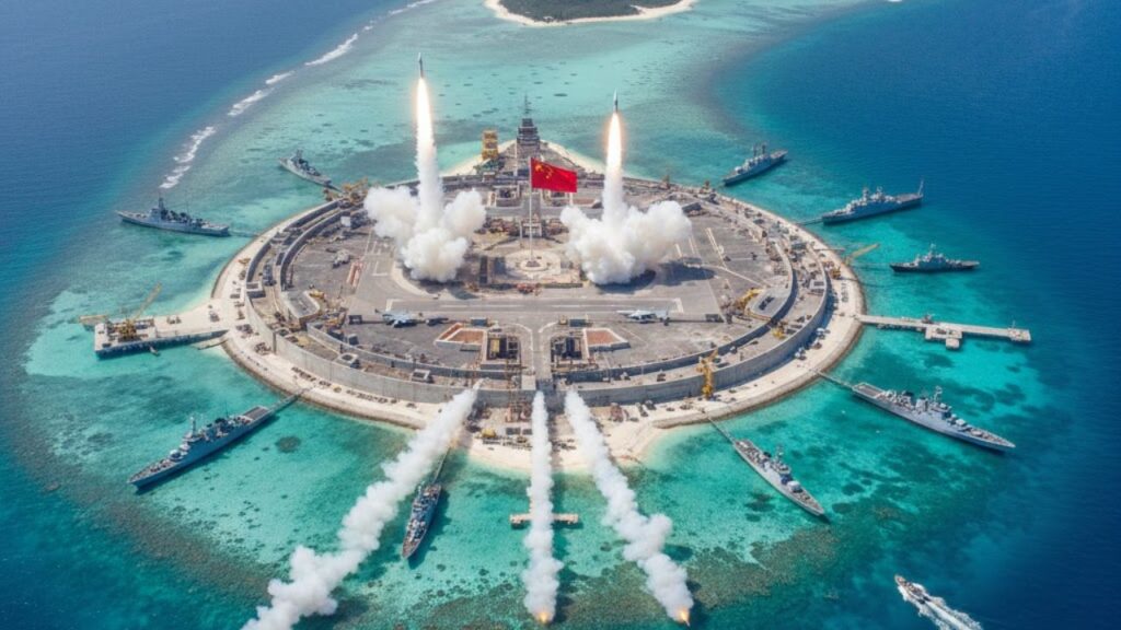
Fiery Cross Reef is a clear example. Once barely visible above water at high tide, it served mainly as a reference point for fishermen. By 2014, dredging vessels surrounded it, pumping sand until a new island took shape, large enough to support a 3,000-meter runway.
Within years, hangars, fuel depots, radar domes, and barracks followed. Satellite photos documented each step. One moment showed raw sand. The next revealed asphalt strips, helipads, and defensive positions. What once disappeared beneath waves became a permanent, functioning base.
The strategy is straightforward. Many of these reefs barely qualified as land under international law. By converting them into lasting outposts, China reinforced long-standing map claims over waters also claimed by the Philippines, Vietnam, Malaysia, and Brunei.
Concrete does not negotiate. Every pier and runway quietly signals that the sea is now monitored, supplied, and defended.
The Blueprint: How Artificial Islands Are Built
The process begins with shallow water—a reef, sandbar, or submerged ring exposed at low tide. Then come the dredgers, vast ships equipped with metal cutters that scrape the seabed, vacuuming up sand and crushed coral.
This slurry is pumped through heavy pipes and dumped onto the reef until solid ground rises above the waves. Once exposed, construction accelerates. Foundations are laid. Sea walls are reinforced. Runway bases are compacted. Each layer adds height, weight, and resistance to storms.
What starts as a muddy platform can become an island with streetlights and paved roads within months.
In the Spratlys, China didn’t stop at one outpost. It created a network. Subi Reef, Mischief Reef, and Fiery Cross form the core, supported by smaller fortified sites like Gaven and Johnson South. Together, they function like a chain of strategic positions spread across 1.3 million square miles of sea.
For Filipino fishermen, the transformation feels personal. In the 1990s, they sheltered at Mischief Reef during storms, sharing space with crews from neighboring countries. In 1995, Chinese-built “fishermen’s shelters” appeared. Today, the same reef is encircled by concrete structures and patrol vessels.
 Goodbye Hair Dye for Grey Hair: The Conditioner Add-In That Gradually Restores Natural Colour
While the method appears technical—engineering capacity, logistics, dredging power—the real aim is to change realities faster than diplomacy can respond. A 2016 ruling by a UN tribunal declared that these artificial islands create no new legal rights. Construction continued regardless.
International law moves slowly. Dredgers do not.
Global Reactions and Why It Matters Beyond the Region
The United States frames its response around freedom of navigation. In practice, this means naval destroyers passing through contested waters and patrol aircraft flying steady routes near the islands.
The routine rarely changes. Ships sail through. Chinese radio warnings follow. Calm replies are issued. The vessels continue on course. It is a carefully managed display of resolve designed to avoid escalation.
For people watching from afar, the issue can seem distant—legal claims, shipping lanes, artificial land. Yet the impact is tangible. Major trade routes carrying fuel, electronics, and food move through these waters. Any disruption affects prices, supply chains, and jobs far beyond Asia.
China maintains that the islands serve civilian purposes such as weather monitoring, navigation support, and search-and-rescue operations. Military installations are described as defensive necessities. Neighboring states and Western governments see a calculated effort to shift regional power without open conflict.
Key Signals to Watch
- Language choices like “historic rights,” “nine-dash line,” and “military-civil fusion” reveal how civilian and military roles merge.
- Construction speed shows strategic urgency as bare platforms quickly become full bases.
- Fishermen’s reports of harassment or blocked access often reflect reality more clearly than official statements.
- Silence from smaller nations often signals pressure or limited options, not agreement.
- Environmental loss remains invisible in military briefings but represents a permanent cost.
Beneath the Concrete and the Future It Creates
Under each artificial island lies an ecosystem that took centuries to form. Coral reefs that sheltered fish and sustained livelihoods are now sealed beneath concrete.
Once covered, reefs do not return. A runway cannot be reversed into living coral within a human lifetime.
At the same time, these structures are now fixed realities. Runways, radar stations, and barracks stand on land that did not exist fifteen years ago. No nation is likely to remove them voluntarily.
The central question is no longer whether they will remain, but how the region will coexist with them. Some analysts see future bargaining tools. Others worry about their role in a potential Taiwan crisis. Many regional communities simply hope they do not become the trigger for a conflict they never sought.
From a distance, it may seem like a story of remote reefs and diplomatic language. In truth, the same forces shaping these islands are altering coastlines worldwide—ports expanding, mangroves disappearing, shorelines redrawn.
When concrete meets water, power tends to favor permanence. Whether future choices allow for flexibility, restraint, or compromise remains uncertain. What is clear is that contested seas are increasingly being defined, quite literally, one runway at a time.

| Key point | Detail | Value for the reader |
|---|---|---|
| Concrete as strategy | China turned semi‑submerged reefs into permanent military outposts through massive dredging and construction | Helps decode headlines about “island‑building” and understand what is physically changing at sea |
| Power of “facts on the ground” | Artificial islands exist faster than international law or diplomacy can respond | Shows why rulings and protests often seem to lag behind reality |
| Everyday impact | Disputes over these waters affect trade routes, energy flows and regional stability | Connects distant maritime disputes to prices, jobs and daily life far from the South China Sea |