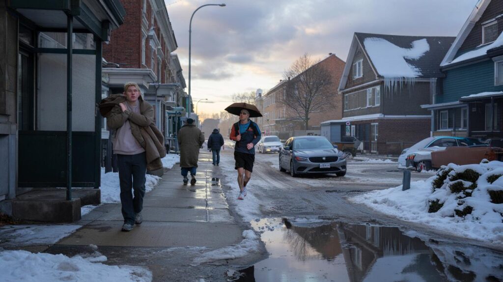
It was the weird silence in the street one early morning in late January, when someone stepped outside expecting a knife-sharp cold and instead met a soft, almost springlike air. The snow that had squeaked under boots the day before had turned to a damp crust, sagging off car roofs, sliding in slow motion from gutters. A jogger passed in shorts, shaking his head and laughing like he didn’t quite trust what his own skin was telling him.
What an “early Arctic breakdown” really looks like on the ground
On the models, the story starts with a familiar swirl of colors: a weakened polar vortex, high-pressure domes bulging where they normally don’t, and tongues of polar air spilling south like a knocked-over glass. On the ground, it looks and feels messier.
One city wakes up to rain on snow, another to a violent temperature swing of 20 degrees in a day. That “impossible” thaw in late January suddenly becomes the new normal for the week. And in the middle of it, people do what they always do: shovel, scrape, layer up, peel off, grumble about the forecast, then tap their phones again for the next update, hoping this one will stick.

Meteorologists watching upper-air data this year say the Arctic’s usual cage of cold is opening earlier than expected. The jet stream – that fast-moving river of air that usually keeps the deep freeze corralled – is wobbling like a loose rope.

In practice, that has meant record or near-record warmth across parts of Europe, rainstorms riding on March-like systems in the U.S., and pockets of brutal cold dropping into regions that had felt almost smugly mild days before. One forecaster described the pattern as “February arriving with its dial already turned to 11.” It sounds theatrical, but the numbers back it up.
When meteorologists talk about an “Arctic breakdown,” they’re not picturing a single storm. They’re talking about the structural weakening of the polar vortex and the way that weakness ripples down through layers of the atmosphere until your backyard weather goes sideways.
Climate change doesn’t cause every twist in the jet stream, yet a warmer planet is loading the dice. Snow and ice retreat earlier, the Arctic heats up faster than mid-latitudes, and the contrast that once powered a stable winter circulation gets blurred. The result is not a neat slide from cold to warm. It’s whiplash. And this year, that whiplash is arriving weeks ahead of schedule, right when people thought winter was finally “settling in.”
How to live with a winter that won’t sit still
Start simple: treat February like it’s become the wild card month of the year. Instead of assuming “deep winter” rules, think of it as a weather roller coaster where you pack for three seasons in one week.
That can be as basic as keeping a small “swing kit” in your hallway or car: light gloves and a hat, but also sunglasses and a thin rain shell. Rotate footwear more aggressively than your habits want you to. On a Monday, you might need boots with good traction for flash-freeze mornings. By Thursday, the same sidewalks could be sloppy with meltwater and puddles deep enough to soak sneakers in one misstep.

We’ve all been there, that moment when a midwinter warm spell tricks you into storing the heavy coat, only for a sharp cold blast to slam back the next day. This year, forecasters warn that such swings could be sharper and more frequent as the Arctic breakdown progresses into February.
The temptation is to plan based on “typical” winter patterns you grew up with. That’s where a lot of frustration creeps in. The plain truth is: those old patterns are loosening their grip. The emotional fatigue is real too — parents juggling school closures, workers gauging commute risks, older people weighing a trip to the grocery store against icy steps. A little extra flexibility in your daily playbook can lower your stress more than any app alert.
Meteorologist Claire Parsons, who’s been tracking polar vortex behavior for over a decade, puts it bluntly: “We’re not just forecasting storms anymore, we’re forecasting stress. An early Arctic breakdown means people are trying to live normal lives in a season that refuses to behave normally.”
- Watch the pattern, not just the daily iconInstead of only checking tomorrow’s high, glance at the 7–10 day trend. Rapid swings – especially when February looks like April for a few days – are a hint you’re seeing the fallout from a disrupted Arctic.
- Plan “soft,” not “hard,” for outdoor eventsKeep backup dates, flexible venues, or hybrid options if you’re hosting anything in late winter. That birthday hike, that small market, that community game – build in an escape hatch from wind chills and rain-on-snow glare ice.
- *Respect the messy middle days*
Those are the ones right after a big thaw or just before a cold crash, when refreezing can turn wet streets into near-invisible ice. Let’s be honest: nobody really does this every single day. Yet those who slow down a bit on these transition days are the ones who end up with fewer falls, fewer car dings, and fewer regrets.
What this strange February is really telling us
There’s a quiet dissonance in watching crocuses poke up in one region while another digs out from a snowstorm fueled by the same broken Arctic pattern. People share photos of blooming trees in January, then scroll down to see frozen pipes and whiteouts in the next post. It feels less like different planets and more like one atmosphere losing its old script.
An unusually early Arctic breakdown is not a sci‑fi headline, it’s a lived experience playing out in wet socks, busted roofs, thawed fields, and canceled flights. For farmers watching soil that never quite freezes, for city crews wrestling with potholes from repeated freeze–thaw cycles, for kids whose mental image of “February” quietly shifts each year, this is the new baseline they’ll remember.
 Meteorologists warn February may open with an Arctic shift scientists are struggling to model
| Key point | Detail | Value for the reader |
|---|---|---|
| Earlier Arctic breakdown | Weakened polar vortex and distorted jet stream weeks ahead of usual timing | Helps explain why February feels more chaotic and less like “old-fashioned winter” |
| Weather whiplash | Rapid swings between thaw, rain, and sudden cold blasts tied to Arctic disruption | Guides how to plan daily life, travel, and outdoor activities with more flexibility |
| Living with the pattern | Small practical habits: watch trends, prepare for transitions, stay emotionally flexible | Reduces stress, risk, and frustration as this new type of winter becomes more common |
FAQ:
- Question 1What does “Arctic breakdown” actually mean in simple terms?
- Question 2Is this early breakdown proof that climate change is getting worse?
- Question 3Should I expect more snow or less snow during a disrupted February?
- Question 4Why do forecasts seem to change so quickly during these patterns?
- Question 5What’s one practical thing I can do this month to adapt to these swings?