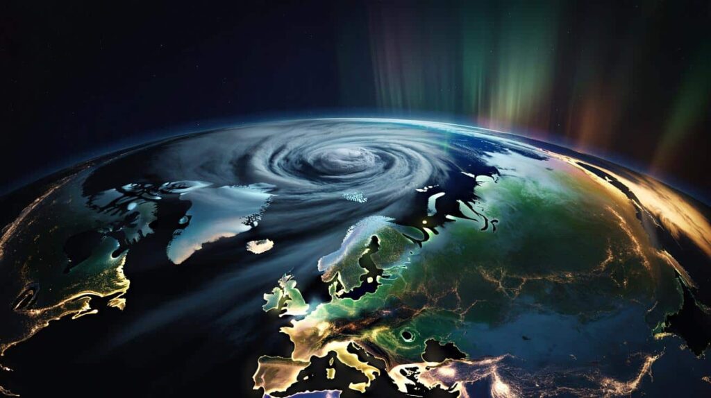
The first hint that something was off came in the sound of the wind. Not the usual February gusts rattling windows, but a strange, high-altitude roar meteorologists could see on their screens long before any of us felt it in our bones. In offices lit by soft blue monitors, forecasters watched the polar vortex — that huge, icy whirl of air that usually stays locked over the Arctic — start to bend, stretch, and twist in ways that didn’t match the textbook.
Outside, most people just zipped their coats, refreshed their weather apps, and muttered about another weird winter. Inside the data, though, a much louder story was forming.
Something rare was unfolding above our heads, and it was already rewriting the script for February.

An Arctic engine suddenly shifting gears
A few dozen kilometers above the North Pole, the polar vortex has started doing something that’s making seasoned scientists lean closer to their screens. Instead of spinning neatly like a cold, contained top, it’s wobbling and weakening, shoved off center by powerful waves of energy rising from the lower atmosphere.
 French Foreign Trade Booms In This Chinese Region With +32.7% Exports In A Year To €432 Million
For early February, the shift is unusually strong. Several climate monitoring groups say the current disruption ranks among the most intense events ever observed for this time of year, based on satellite measurements of stratospheric winds and temperatures. In plain terms: the Arctic’s cold “ceiling fan” is glitching mid-season, and that usually means the air below doesn’t stay where it’s supposed to.
One European forecast center flagged the first sign late in January: stratospheric winds above 60°N were dropping sharply, then threatening to reverse direction altogether. That reversal, known as a sudden stratospheric warming, is the meteorological red alert that the polar vortex is cracking.
A similar event back in 2018 helped unleash the “Beast from the East,” the brutal cold snap that froze much of Europe and parts of Asia. Another one in 2021 helped fuel the deadly Texas freeze that burst pipes and pushed the state’s power grid to the edge. In both cases, the trigger wasn’t visible from the ground at first. It started quietly, high above the Arctic, just like now.
So what’s pushing the vortex around this time? Researchers point to a cocktail of factors: persistent blocking highs over the North Pacific and North Atlantic, warm pools of ocean water, and an already disturbed jet stream with deep meanders. Those big ridges of high pressure act like mountains in the sky, sending waves upward that smash into the stratosphere.
When that energy hits, the polar vortex stretches like dough, then can split or collapse. Cold air that had been spinning in a tight circle is suddenly free to spill southward in lumpy, uneven blobs. *This is why some regions can be basking in freak warmth while others are hammered by dangerous, record-breaking cold from the very same event.*
What this means for your street, not just the stratosphere
Meteorologists aren’t just staring at pretty maps — they’re trying to translate this high-altitude drama into something visceral: icy sidewalks, heavy snow, slushy commutes, flash thaws. The emerging consensus is that the next few weeks could bring a messy pattern of flips and extremes for parts of North America, Europe, and Asia.
The most likely scenario? Shots of intense cold dropping into mid-latitudes in waves, separated by windows of oddly mild air. That back-and-forth makes planning hard. One week you’re stacking firewood and layering fleece. The next, your winter coat feels too heavy and the snow banks start to melt from the bottom up.
We’ve all been there, that moment when you step outside and the air doesn’t match what your mind thinks February should feel like. In Germany, forecasters are already warning of a “roller coaster” pattern: bitter intrusions of Arctic air, then sudden thaws fueling freezing rain. In the U.S., long-range models hint at renewed cold outbreaks east of the Rockies after brief, almost springlike breaks.
Japan’s meteorological agency has flagged increased odds of heavy snow on the Sea of Japan side if the vortex disruption lines up with the right wind patterns. At the same time, parts of southern Europe and the Mediterranean could swing warmer and wetter, trading deep cold for flood risk. One rare stratospheric shift, dozens of local stories playing out under it.
 In Bulgaria, a strange rock found by chance in a forest may be the very first star map in history
Climatologists are careful not to blame every strange winter on the polar vortex, yet this event is adding fuel to an already unstable fire. Background warming of the Arctic means the temperature contrast between polar and mid-latitude regions is shifting. Some studies suggest that a weaker, wobblier vortex might become more common as sea ice shrinks and heat escapes from newly open water.
Not everyone agrees on the strength of that link, and the science is still maturing. Still, there’s a growing sense that what used to be “once in a decade” winter dynamics might be nudging toward “once every few years.” Let’s be honest: nobody really reads the technical papers on this, but plenty of people feel that winters just don’t behave the way they used to.
How to live with a winter that won’t sit still
For anyone not glued to upper-air charts, the big question is simple: what do I do with this information? Start small and practical. Think in flexible layers — clothing, plans, even budgets. If your region is in the potential path of vortex-driven cold, that means having a backup heating option, a stash of shelf-stable food, and a way to charge your phone if power flickers.
Check local forecasts more often than you normally would in February. The atmosphere is jumpy right now, and small shifts up high can mean big changes on the ground within a week. Treat “outlier” forecasts — that sudden cold plunge at day 8, or strange ice storm risk — as signals to prepare, not as guaranteed doom.
A common mistake is treating winter as a single storyline: either “mild” or “brutal.” This kind of polar vortex disruption tends to produce patchwork winters, not clean labels. That means you might prepare for cold, then second-guess yourself when a warm spell shows up. Don’t take the bait.
Another misstep is focusing only on snow totals. The real risks often come from ice, rapid temperature swings, and overloaded infrastructure. Pipes freeze, then thaw and burst. Roads glaze over, then refreeze after sunset. Power grids that handled last week’s cold can stumble when demand spikes twice in the same month. Behind every statistic are ordinary people trying to get kids to school, keep elderly relatives warm, and protect small businesses from yet another surprise bill.
“From a stratospheric perspective, this is one of the more intense February disruptions we’ve seen in the modern record,” says one senior atmospheric scientist at a European research center. “What worries me most isn’t just the cold itself, but the speed of the swings. Systems — and people — don’t adapt well to whiplash.”
- Track your region’s outlook
Follow trusted national or regional meteorological agencies, not just viral tweets. - Build a simple “weather buffer”
Warm clothes, extra blankets, basic backup power, and a few days of food and medicine. - Plan for travel uncertainty
If you have flights or long drives, consider flexible tickets and keep an eye on 5–10 day outlooks. - Protect vulnerable neighbors
Check in with older adults, people with chronic illness, or those without reliable housing. - Think beyond this year
Use this strange winter as a prompt to review how your home, workplace, or city handles weather shocks.
A glimpse of winters to come?
This rare early-season polar vortex shift is more than a curiosity for weather geeks. It’s a real-time stress test for our homes, grids, and habits, playing out in the background of a warming planet. On one side, you have decades of carefully compiled reanalysis data showing just how unusual this February’s stratospheric disruption is. On the other, you have the ordinary chaos of daily life: kids’ sports schedules, work commutes, grocery runs, fragile budgets.
The next few weeks will bring stories — of unexpected snowstorms, broken records, canceled plans, maybe even quiet afternoons where nothing dramatic happens at all. The question is how we absorb this pattern into our sense of what “normal winter” means. Do we still expect smooth, predictable seasons, or do we start living as if sharp swings and odd juxtapositions are here to stay?
Some people will shrug and move on as soon as the first crocuses push through. Others will remember that, high above the clouds, the Arctic engine briefly lost its rhythm, and the whole hemisphere felt the wobble.

| Key point | Detail | Value for the reader |
|---|---|---|
| Unusual February intensity | Stratospheric winds and temperatures show one of the strongest early-season vortex disruptions in the modern record. | Helps you understand why forecasts sound more urgent — and why this winter feels different. |
| Local impacts are uneven | Some regions face Arctic blasts and snow, others get mild, wet spells or ice storms. | Encourages checking region-specific forecasts instead of assuming a single global outcome. |
| Practical preparation matters | Flexible plans, basic supplies, and travel caution reduce stress during weather whiplash. | Turns abstract climate and stratosphere talk into concrete steps you can act on this month. |
FAQ:
- Question 1What exactly is the polar vortex, and should I be scared of it?
- Answer 1The polar vortex is a large, cold low-pressure system high over the Arctic that usually stays put. It’s not a single storm, and it’s not new. When it weakens or shifts, it can allow cold air to spill south, but it’s one piece of a much bigger atmospheric puzzle, not a movie-style monster.
- Question 2Does a strong vortex disruption always mean a huge snowstorm where I live?
- Answer 2No. A disrupted vortex raises the chances of cold outbreaks and unusual patterns, but local snow, rain, or ice depend on timing, moisture, and storm tracks. Some areas may see blockbuster storms, others mainly cold and dry, and some stay relatively mild.
- Question 3Is climate change causing this rare February event?
- Answer 3Scientists are still debating the exact link. A warming Arctic and shrinking sea ice likely influence the jet stream and the polar vortex, but the relationship is complex. This event fits a pattern of more frequent extremes, yet no single disruption can be blamed on climate change alone.
- Question 4How far ahead can experts really predict polar-vortex-driven cold waves?
- Answer 4Stratospheric disruptions are often detected 1–2 weeks in advance, sometimes longer. Translating those signals into precise local impacts is much harder. Expect decent guidance at the regional scale, but don’t rely on exact snow totals until a few days out.
- Question 5What’s the smartest thing I can do right now?
- Answer 5Check the 10–15 day outlook from a trusted national weather service, prepare a modest “weather buffer” at home, and build flexibility into your plans. You don’t need to panic — just give yourself a little margin for a February that refuses to stay in its lane.