The alert didn’t come with sirens or breaking-news banners. It arrived as a quiet chart in an email inbox, a set of jagged lines climbing where they should have been flat or falling. On a gray January morning, a group of meteorologists watched their screens in a windowless office, coffee growing cold beside keyboards, as the Arctic’s vital signs blinked red. Wind patterns were warping, ocean warmth pressing further north, polar night not delivering the deep freeze it once did.
One of them finally said what everyone else was thinking: “This looks like February, not the Arctic we grew up with.”
Outside, the city went about its business under a pale winter sun. Inside, people who read the air for a living were quietly terrified.

Something up north is starting to break.

When the Arctic winter stops behaving like winter
On paper, the numbers sound abstract: Arctic temperatures running 10°C above normal in some regions, sea ice forming weeks late, snowfall patterns shifting thousands of kilometers away. On real screens in real forecast rooms, those numbers translate into a distinctly human reaction: raised eyebrows, long silences, someone zooming into a map again and again, hoping the colors will change.
Meteorologists across Europe and North America are now seeing the same thing. The patterns that once made February almost boring to forecast in the far north are glitching. The air over the Arctic is warmer, puffier, more chaotic. The frozen ceiling that used to lock winter into place is thinning.
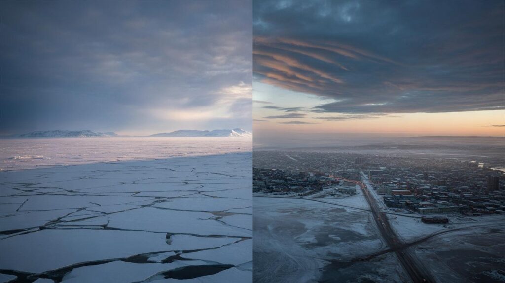
Look at the satellite loops from the last few weeks and the story jumps out. Arms of moist air keep punching up from the Atlantic and Pacific into what should be the world’s freezer. Sea ice in the Barents and Kara Seas sits at shockingly low levels for this point in winter.
In Alaska, villages that usually rely on thick coastal ice for hunting and travel have watched it form late, or not at all. Parts of Greenland have seen rain in months that traditionally meant nothing but dry powder. The European Centre for Medium-Range Weather Forecasts has flagged unusual wave patterns rippling around the polar vortex, tugging on the jet stream like a fraying rope.
For forecasters, the phrase “Arctic breakdown” doesn’t mean the North Pole suddenly melts in a day. It means the old rules that governed cold, wind, and ice stop working. The Arctic acts less like a stable, frozen dome and more like a restless, leaking system.
This breakdown shows up as sudden warm intrusions into the polar night, strange kinks in the jet stream, and winter storms popping up where they don’t belong. *What scares the people reading the data isn’t one wild map; it’s the feeling that the baseline itself has shifted.*
The models, updated with the latest atmospheric data, are now hinting that this shift could spike as early as February.
What February could bring far from the Arctic Circle
If all this stayed locked above 70° North, it would be a worrying science story, not a lived one. But the atmosphere does not respect our mental borders. Once the polar circulation loses its tight, cold grip, the jet stream begins to wobble. Those wobbles can send Arctic air plunging south in one place while shunting freak warmth north in another.
For someone in, say, Chicago, Paris, or Seoul, that can mean whiplash weeks: T-shirt weather followed by a sudden, bone-deep freeze. Then floods in places that were supposed to be frozen solid. Then nothing but gray, damp days when the forecast used to be simple: cold, maybe snow, end of story.
We’ve all been there, that moment when you pull back the curtain in late winter and the season outside feels… off. In February 2021, a displaced lobe of the polar vortex slammed Texas with brutal cold, knocking out power for millions. That kind of event was once considered a freak accident of the atmosphere. Now, similar pressure patterns are showing up more often in the data.
This winter, Italian vineyards have already seen budding vines threatened by weirdly warm then sharply cold stretches. Scandinavian ski resorts are trucking in artificial snow while rain falls on normally icy tracks. In Japan, record-warm January days have collided with sudden bursts of heavy, wet snow that overload roofs and roads. Each episode seems local and isolated, yet meteorologists can trace them back to the same warping Arctic heartbeat.

The logic behind it isn’t mystical. An Arctic that warms faster than the rest of the planet reduces the temperature contrast between pole and equator. That contrast is the energy that powers the jet stream, the high-altitude river of air that keeps weather patterns more or less in their lanes.
With that contrast weakened, the jet stream slows and meanders, like a tired river spilling over its banks. Cold air pools where it didn’t used to. Warm air surges into polar regions during months that once reliably built sea ice. **What used to be rare “blocking patterns” now linger longer**, locking some regions into endless rain while others sit under stubborn high pressure and drought.
This is what an atmospheric breakdown looks like: not a Hollywood disaster scene, but a subtle unhinging of the familiar.
How to live with a winter that no longer follows the script
No single household can steady the jet stream. Yet there are small, almost stubborn actions that help you keep your footing as the old climate patterns fade. The first is simple: stop planning winter as if it were still 1995.
Think in ranges, not certainties. If you depend on snow for income or travel, build backup plans earlier. If you live in a flood-prone area, treat winter rain with the same seriousness you used to reserve for spring storms. **Check local forecasts more than once a day during unsettled periods**, because wild swings now play out over hours, not just weeks.
There’s a quiet kind of stress that comes with opening a weather app and never quite trusting what it says. That low-level tension is real, and pretending it isn’t there doesn’t help. This is where community habits matter.
Talk about the odd warmth, the late ice, the strange rain with neighbors and coworkers. Not in a doom spiral, but in a “how are we adapting?” way. Farmers already swap notes on shifting planting windows. Parents can trade strategies for dressing kids for days that go from sun to sleet between lunch and dinner. Let’s be honest: nobody really reads every climate report or follows every scientific thread. But almost everyone feels when the air outside is no longer playing by the old rules.
Meteorologists who track these shifts aren’t just issuing abstract warnings. Many of them are quietly changing their own lives on the back of the data they see every day.
“February used to be the month I could promise my kids solid ice for skating,” a Norwegian forecaster told me. “Now I tell them, ‘We’ll see on Thursday.’ The models just don’t give us the same confidence anymore.”
- Follow regional meteorological services, not just generic apps.
- Photograph and note local “weird weather” — it sharpens your awareness.
- Spread out risk: don’t hinge business or travel on one precise winter scenario.
- Learn basic flood, storm, and heat safety, even for seasons you never linked them to.
- Support local reporting that connects your town’s weather to global Arctic shifts.
The Arctic is breaking in slow motion, and we’re all in the frame
Standing in a city street, it’s easy to feel that the Arctic is a distant headline, as far away as the moon. You glance up at a hazy February sky, juggle a coffee, dodge a puddle that should have been snow, and then your day swallows you whole. Yet the same air molecules above your head have been twisted and steered by what’s unravelling over the pole.
This is the unsettling intimacy of an atmospheric breakdown. It turns maps into mirrors. The warning signs that meteorologists see in those jagged charts are not just about polar bears or shipping lanes. They’re about where rivers will flood, which crops might fail, how much energy your city will burn in a cold snap that arrives late and leaves too soon.
Some people will respond to this with activism, pushing harder than ever for emissions cuts, cleaner transport, or local resilience plans. Others will respond more quietly: insulating a drafty room because winters are now both milder and more erratic, joining a volunteer emergency team, or simply paying closer attention to the sky. Both responses matter.
The plain truth is that the Arctic of our childhood maps is gone, and what replaces it will keep shaping our daily lives in ways we’re only beginning to feel. How we talk about that shift — in families, in cities, in politics — will decide whether “Arctic breakdown” becomes just another frightening phrase, or a turning point that nudged us to live differently on a rapidly changing planet.

| Key point | Detail | Value for the reader |
|---|---|---|
| Arctic breakdown signals | Unusual warmth, low sea ice, warped jet stream emerging as early as February | Helps readers understand why winter feels so unstable and unpredictable |
| Local consequences | Weather whiplash, surprise cold snaps, winter floods, and disrupted snow seasons | Connects distant Arctic data to everyday life, travel, and work decisions |
| Practical adaptation | Flexible planning, closer tracking of forecasts, community-level awareness | Gives concrete steps to stay safer and less anxious in a shifting climate |
FAQ:
- What do meteorologists mean by “Arctic breakdown”?They use it to describe a loss of the Arctic’s former stability: weaker cold pools, disrupted polar vortex, and erratic jet stream behavior that spill over into mid-latitude weather.
- Is this just a natural cycle, like past weird winters?Natural variations exist, but long-term data show the Arctic warming about four times faster than the global average, with sea ice and snow cover trending sharply downward, beyond past cycles.
- Could February really see extreme impacts from this breakdown?Yes. Current models suggest that late winter 2026 could bring unusual warm pulses into the Arctic and sharp cold or stormy spells in North America, Europe, and Asia linked to those shifts.
- Does an Arctic breakdown mean every winter will be warmer?Not steadily. It means more volatility: some regions may get record warmth, others sudden cold waves, all against a background of overall planetary warming.
- What can ordinary people actually do in response?Adapt locally — update winter safety habits, follow reliable forecasts, push for resilient infrastructure — and act politically and personally to cut emissions that keep driving Arctic change.